Lake Powell
| Lake Powell | |
|---|---|
 |
|
| Location | Utah / Arizona |
| Lake type | reservoir |
| Primary inflows | Colorado River, Escalante River, San Juan River |
| Primary outflows | Colorado River |
| Catchment area | 67,000 km2 (26,000 sq mi) |
| Basin countries | United States |
| Max. length | 299 km (186 mi) |
| Max. width | 40 km (25 mi) |
| Surface area | 658 km2 (254 sq mi) |
| Average depth | 40 m (132 ft) |
| Max. depth | 170 m (560 ft) |
| Water volume | full: 30 km3 (24,000,000 acre·ft) current: 19.5 km3 (15,800,000 acre·ft)[1] |
| Residence time | 7.2 years |
| Shore length1 | 3,057 km (1,900 mi) |
| Surface elevation | full: 1,127 m (3,700 ft) current: 1,108.55 m (3,637 ft)[2] |
| 1 Shore length is not a well-defined measure. | |
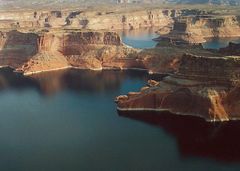
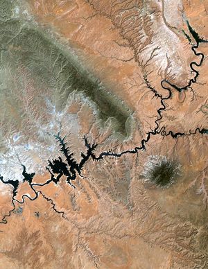
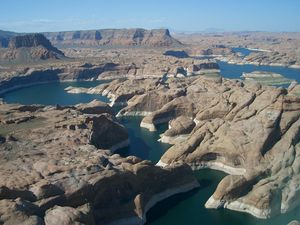
Lake Powell is a reservoir on the Colorado River, straddling the border between Utah and Arizona (most of it, along with Rainbow Bridge, is in Utah). It is the second largest man-made reservoir in the United States behind Lake Mead, storing 24,322,000 acre feet (30 km³) of water when full. Lake Powell was created by the flooding of Glen Canyon by the controversial Glen Canyon Dam, which also led to the creation of Glen Canyon National Recreation Area, a popular summer destination. The reservoir is named for explorer John Wesley Powell, a one-armed American Civil War veteran who explored the river via three wooden boats in 1869. In 1972, Glen Canyon National Recreation Area was established. It is public land managed by the National Park Service, and available to the public for recreational purposes. It lies in parts of Garfield, Kane, and San Juan counties in southern Utah, and Coconino County in northern Arizona.
Lake Powell is a storage facility for the Upper Basin states of the Colorado River Compact (Colorado, Utah, Wyoming, and New Mexico). The Compact specifies that the Upper Basin states are to provide a minimum annual flow of 8.23 million acre feet (10 km³) to the Lower Basin states (Arizona, Nevada, and California).
Contents |
History
In the 1940s and early 1950s, the U.S. Bureau of Reclamation planned to construct a series of Colorado River dams in the rugged Colorado Plateau province of Colorado, Utah and Arizona. Glen Canyon Dam was born of a controversial damsite the Bureau selected in Echo Park, in what is now Dinosaur National Monument in Colorado. A small but politically effective group of objectors led by David Brower of the Sierra Club succeeded in defeating the Bureau's bid, citing Echo Park's natural and scenic qualities as too valuable to submerge.
But by agreeing to a relocated damsite near Lee's Ferry, between Glen and Grand Canyons, Brower did not realize what he had gambled away. At the time, Brower had not actually been to Glen Canyon. When he later saw Glen Canyon on a river trip, Brower discovered that it had the kind of scenic, cultural, and wilderness qualities often associated with America's national parks. Over 80 side canyons in the colorful Navajo Sandstone contained clear streams, abundant wildlife, arches, natural bridges, and thousands of Native American archeological sites. By then, however, it was too late to stop the Bureau and its commissioner Floyd Dominy from building Glen Canyon Dam. Dominy was a firm believer in putting the river to human use, once saying "Now I admit that nature can't improve upon man. We're probably the supreme being." Brower believed the river should remain free, and would forever after consider the loss of Glen Canyon his life's ultimate disappointment.
Construction on Glen Canyon Dam began with a demolition blast keyed by the push of a button by President Dwight D. Eisenhower at his desk in the Oval Office on October 1, 1956. The first blast started clearing tunnels for water diversion. On February 11, 1959, water was diverted through the tunnels so dam construction could begin. Later that year, the bridge was completed, allowing trucks to deliver equipment and materials for the dam, and also for the new town of Page, Arizona.
Concrete placement started around the clock on June 17, 1960. The last bucket of concrete was poured on September 13, 1963. Over 5 million cubic yards (4,000,000 m³) of concrete make up Glen Canyon Dam. The Dam is 710 feet (216 m) high, with the surface elevation of the water at full pool being approximately 3700 feet (1100 m). Construction of the Dam cost $155 million, and 18 lives were lost in the process. From 1963 to 1966, turbines and generators were installed for hydroelectricity. On September 22, 1966, Glen Canyon Dam was dedicated by Lady Bird Johnson.
Upon completion of Glen Canyon Dam on September 13, 1963, the Colorado River began to back up, no longer being diverted through the tunnels. The newly flooded Glen Canyon formed Lake Powell. It took 17 years for the lake to rise to the high water mark, on June 22, 1980. Since then the lake level has fluctuated considerably depending on the seasonal snow runoff from the mountains.[3][4][5]
Colorado River flows have been below average since the year 2000, leading to lower lake levels. In the winter of 2005 (before the spring run-off) the lake reached its lowest level since filling, an elevation of 3,550 feet (1,080 m) above sea level, which was approximately 150 feet (46 m) below full pool (elevation 3700'). Since 2005 the lake level has risen 78 feet (24 m), to a high elevation of 3,628 feet (1,106 m) above sea level in spring/early summer 2008. As of July 4, 2009, the lake level had exceeded 3640'.
Geology
Glen Canyon was carved by differential erosion from the Colorado River over an estimated 5 million years. The Colorado Plateau, through which the canyon cuts, arose some 11 million years ago. Within that plateau lie layers of rock from over 300 million years ago to the relatively recent volcanic activity. Pennsylvanian and Permian formations can be seen in Cataract Canyon and San Juan Canyon. The Moenkopi Formation, which dates from 230 million years ago (Triassic Period), and the Chinle Formation are found at Lees Ferry and the Rincon. Both formations are the result of the ancient inland sea that covered the area. Once the sea drained, windblown sand invaded the area, creating what is known as Wingate Sandstone. The more recent (Jurassic Period) formations include Kayenta Sandstone, which produces the trademark blue-black "desert varnish" that streaks down many walls of the canyons. Above this is Navajo Sandstone, the result of more compressed sand dunes. Many of the arches, including Rainbow Bridge, lie at this transition point. This period also includes light yellow Entrada Formations, and the dark brown, almost purple Carmel Formation. These latter two can be seen on the tops of mesas around Wahweap, and the crown of Castle Rock and Tower Butte. Above these layers lie the Straight Cliffs Sandstone and conglomerate shales that make up the Kaiparowits Plateau and San Rafael Swell to the north of the lake.
The confluences of the Escalante River and San Juan River lie within Lake Powell. The slower flow of the San Juan river has produced goosenecks where 5 miles (8.0 km) of river are contained within 1-mile (1.6 km) on a straight line.
Zebra mussel policies for Lake Powell
Zebra and Quagga mussels first appeared in the United States in the 1980s. The mussels were initially brought to the United States through the ballast water of ships entering the Great Lakes. These aquatic invaders soon spread to many bodies of water in the Eastern United States and have even made their way to the western United States. Currently, Zebra mussels have been detected in several reservoirs along the Colorado River system such as Lakes Mead, Mojave, and Havasu. Arizona, California, Nebraska, Kansas, Colorado, Nevada and Utah have all confirmed the presence of larval Zebra mussels in lakes and reservoirs.
Zebra and Quagga mussels can be destructive to an ecosystem due to competition for resources with native species. The filtration of zooplankton by the mussels can negatively impact the feeding for some species of fish. Zebra and quagga mussels can attach to hard surfaces and build layers on underwater structures. The mussels are known to clog pipes including those in hydroelectric power systems, thus becoming a costly and time -consuming problem for water managers in the West.
Control policies have recently been introduced to alleviate the hydroelectric problems as well as ecological problems faced by Western infestation. Beginning in 1999 Lake Powell began to visually monitor for the mussels. In 2001 hot water boat decontamination sites were established at Wahweap, Bullfrog, and Halls Crossing marinas. In January 2007, zebra mussels were detected in Lake Mead and new action plans were announced to prevent the spread of mussels to Lake Powell. However, in August 2007 zebra or quagga larvae were discovered in Lake Powell. Lake Powell introduced a mandatory boat inspection for each water- craft entering the reservoir beginning in June 2009. Effective June 29, 2009, every vessel entering Lake Powell must be inspected by trained personnel. These mandatory inspections will help to prevent vessels from transporting Zebra mussels into Lake Powell. While indefinitely preventing zebra mussels from entering Lake Powell will be difficult, prevention is key to avoiding serious and costly problems in the future. Nearly impossible to reverse infestations, prevention remains the main policy to protect Lake Powell. Recent government support from the American Recovery Act provided additional funding for further research regarding monitoring, control and ecological impacts of Zebra mussels.
Environmental impacts
The environmental impacts of Lake Powell are vast and hold strong implications as toward the stability and state of the Colorado River. One of the immediate effects of the dam was the retention of water at previously unknown levels, filling the canyon country and the areas immediately upstream. This water killed much of the native plant species existing in the canyon and had major effects on wildlife by moving habitats and plant availability. The water has also had major effects on the native fish species as it both changed current, purity, food levels, and temperature as the stopped water could not move as it previously had or as the river naturally would. The effect on water was not shouldered directly by the water behind the dam. Because of the incredibly deep water and slow moving current and water tables, the water that exits from Glen Canyon is noticeably clearer and colder. This holds a major impact on both the plant and animal life on the other side of the dam. Also, the clearer water holds fewer nutrients, which in turn can harm plant life and impact the ecosystem negatively.
Another major impact as a result of the dam’s presence is the second hand effects of added pollutants to the water leaving the lake. Because of its classification as a national recreation center boaters are allowed to recreate in the area. These gas burning boats put pollutants into the water that can corrupt or poison water. Gasoline is not the only contaminant entering the water as a result of tourists and boats. Besides just regular trash left behind by people, floating sewage centers and septic tanks on house boats and cabin cruisers are not perfectly sealed and human waste can potentially seep out, something that can cause e-coli strains in the water, thus being damaging to the water quality and being a potential health hazard for swimmers.
Landmarks
- Glen Canyon Dam, the dam that keeps Lake Powell the way it is today. (location: Lake Powell's Arizona part)
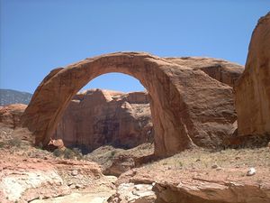
- Rainbow Bridge, one of the world's largest natural bridges. (location: Lake Powell's Utah part)
- Hite Crossing Bridge, the only bridge spanning Lake Powell. Although the bridge informally marks the upstream limit of the lake, when the lake is at its normal high water elevation, backwater can stretch up to 30 miles upstream into Cataract Canyon
Features
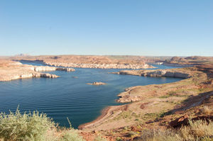
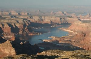
The lake's main body stretches up Glen Canyon, but has also filled many (over 90) side canyons. The lake also stretches up the Escalante River and San Juan River where they merge into the main Colorado River. This provides access to many natural geographic points of interest as well as some remnants of the Anasazi culture.
- Rainbow Bridge National Monument
- Defiance House ruin (Anasazi)
- Cathedral in the Desert
- San Juan goosenecks
- Kaiparowits Plateau
- Hole-in-the-Rock crossing
- the Rincon
- Three-Roof Ruin
- Padre Bay
- Waterpocket Fold
Development
| Facts | |
|---|---|
| Start of storage | March 13, 1963 |
| Completion of initial filling | June 22, 1980 |
| Surface area | 266 mi² |
Because most of the lake is surrounded by steep sandstone walls, access to the lake is limited to developed marinas:
- Lees Ferry Subdistrict
- Page/Wahweap Marina
- Antelope Point Marina
- Halls Crossing, Utah Marina
- Bullfrog Marina
- Hite Marina
The following marinas are accessible only by boat:
- Dangling Rope Marina
- Rainbow Bridge National Monument
- Escalante Subdistrict
Glen Canyon National Recreation Area draws more than two million visitors annually. Recreational activities include boating, fishing, waterskiing, jet-skiing, and hiking. Prepared campgrounds can be found at each marina, but many visitors choose to rent a houseboat or bring their own camping equipment, find a secluded spot somewhere in the canyons, and make their own camp (there are no restrictions on where visitors can stay). Anyone who camps further than a quarter of a mile from a marina, however, must bring a portable toilet. The burying of human waste in Glen Canyon National Recreation Area is prohibited. Pet waste must also be packed out.
The southwestern end of Lake Powell in Arizona can be accessed via U.S. Route 89 and State Route 98. State Route 95 and State Route 276 lead to the northeastern end of the lake in Utah.
Fish species
- Smallmouth Bass
- Largemouth Bass
- Striped Bass
- Crappie
- Sunfish
- Catfish (Channel)
- Northern Pike
- Walleye
References
- ↑ http://lakepowell.water-data.com/ Lake Powell Water Data, Lake Powell Water Data
- ↑ http://lakepowell.water-data.com/ Lake Powell Water Data, Lake Powell Water Data
- ↑ http://www.usbr.gov/uc/water/rsvrs/ops/crsp_40_gc.html Department of the Interior, Bureau of Reclamation, Upper Colorado Region - Operational data
- ↑ http://www.usbr.gov/uc/water/crsp/cs/gcd.html Department of the Interior, Bureau of Reclamation, Upper Colorado Region - Current status
- ↑ http://www.azgfd.gov/h_f/edits/lake_levels.shtml Arizona lakes water level report
- Martin, Russell, A Story That Stands Like a Dam: Glen Canyon and the Struggle for the Soul of the West, Henry Holt & Co, 1989
- Nichols, Tad, Glen Canyon: Images of a Lost World, Santa Fe: Museum of New Mexico Press, 2000
- Abbey, Edward, Desert Solitaire, Ballantine Books, 1985
- Glick, Daniel (April 2006). "A Dry Red Season: Uncovering the Glory of Glen Canyon,". National Geographic. http://www7.nationalgeographic.com/ngm/0604/feature3/index.html. Retrieved 2007-10-21.
- Farmer, Jared, Glen Canyon Dammed: Inventing Lake Powell and the Canyon Country, Tucson: The University of Arizona Press, 1999
- Stiles, Jim, The Brief but Wonderful Return of Cathedral in the Desert, Salt Lake Tribune, June 7, 2005
- Glen Canyon National Recreation http://www.nps.gov/glca/parknews/zebramussel1.htm
- 100th Meridian Initiative http://www.100thmeridian.org/zebras.asp
- Zebra Mussel Information System http://el.erdc.usace.army.mil/zebra/zmis/
- Quagga and Zebra Mussel FAQs http://www.azgfd.gov/pdfs/QuaggaMusselFAQs.pdf
External links
- Report on Lake PowellPDF (503 KiB) by the Utah Division of Water Quality
- Glen Canyon National Recreation Area (National Park Service)
- Glen Canyon Institute - organization in favor of decommissioning Glen Canyon Dam
- Friends of Lake Powell - organization opposed to decommissioning Glen Canyon Dam
- Water Level in Lake Powell, slide show of ten years of images from NASA’s Landsat 5 satellite, showing dramatic fluctuations in water levels in Lake Powell.
- Lake Powell Water Database - water level, basin snowpack, and other statistics
- Arizona Boating Locations Facilities Map
- Arizona Fishing Locations Map
- Where to Fish in Arizona Species Information
- Arizona Lake Levels
- Page/Lake Powell Chamber of Commerce
|
|||||||||||||||||||||||